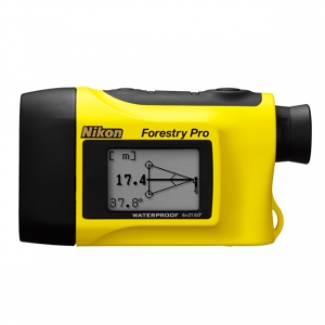
Nikon Forestry Pro
 Klik untuk memperbesar |
Tidak ada gambar tambahan untuk produk ini.
|
Descriptions
- Measurement range: 10-500 m/11-550 yds./33-999 ft.
- In addition to actual distance, horizontal distance, height, angle and vertical separation (difference in height between two targets) measurement functions, three-point measurement (height between two points) is available
- The results are displayed on both internal and external LCD panels. The external panel displays all results simultaneously.
- Target Priority Switch System for measuring overlapping subjects:
First Target Priority mode displays the distance of the closest subject — useful when measuring the distance to a subject in front of an overlapping background.
Distant Target Priority mode displays that of the farthest subject — useful in wooded areas. - High-quality 6x monocular with multilayer coating produces bright, clear images
- Long eye relief design affords eyeglass wearers easy viewing
- Dioptre adjustment function
- Single or continuous measurement (up to 20 seconds)
- Waterproof (up to 1 meter for 10 minutes) but not for underwater usage; the battery chamber is water resistant
- Wide temperature tolerance: -10°C to +50°C
Internal display

- 1. Actual (linear) Distance
- 2. Horizontal Distance
- 3. Height
- 4. Height between two points
- 5. Three-point measurement
- 6. Unit of measure (m/yd.)
 (No unit displayed for ft.)
 - 7. Target mark(
 )
)
- 8. Laser irradiation (
 )
) - 9. Battery condition
- 10. Distant Target Priority mode
- 11. First Target Priority mode
- 12. Angle
- 13. Distance
External display

- 1. Measurement unit (m/yd./ft.)
- 2. Height
- 3. Actual (linear) Distance
- 4. Horizontal Distance
- 5. Angle (º)
Measurement example (Three-point measurement: height between two points)


When three-point measurement is achieved, the height between points 2 and 3 is displayed on the internal LCD with Hor Hgt+Hgt2 (solid), and Hgt(2) and Ang(2) are shown on the external LCD. Points 2 and 3 can be reversed.
Measurement example (two-point height measurement)


When the measurement is successful, you see the height from the base to the top displayed on the internal LCD with Hgt + Hgt2 (solid).
For more information, refer to the external LCD.
"Base" and "Top" can be switched.
| Forestry Pro | ||
|---|---|---|
| Measurement range | Distance:10-500m/11-550 yds./33-999 ft.(*999 ft.: 304.5m/333 yds.) Angle: ±89º |
|
| Distance display (Increment) |
|
|
| Finder | Magnification (x) | 6 |
| Effective objective diameter (mm) | 21 | |
| Actual field of view (º) | 6.0 | |
| Exit pupil (mm) | 3.5 | |
| Eye relief (mm) | 18.2 | |
| Dimensions (LxHxW) (mm) | 130x69x45 | |
| Weight (g) (excluding battery) | 210 | |
| Power source | CR2 lithium battery x 1 (DC3V) Auto power shutoff function equipped (after 30 sec.) |
|
| Safety | Class 1M Laser Product (EN/IEC60825-1:2007) | |
| EMC | FCC Part15 SubPartB class B, EU:EMC directive, AS/NZS, VCCI class B | |
| Environment | RoHS, WEEE | |
The specifications of the product may not be achieved depending on the target object's shape, surface texture and nature, and/or weather conditions.
- Note: The origin of the technique of this Laser Rangefinder with inclinometer is the Surveying Instruments incorporated measuring capability of both distance and angle which were developed by Nikon Corporation. Among such products, especially, the first highly advanced electronic model, the Total Station DTM-1, is the root (Sold in 1985).

 Pencarian
 Online Chatt
 Merek
Merek Produk Promo

 Spesial Produk
 JNE Tracking
